4 theories and principles of settlement

4 Theories and principles of settlements

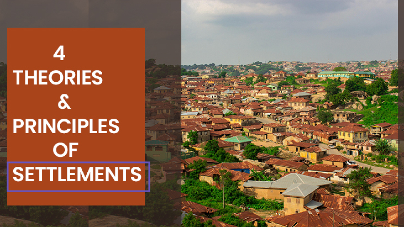
In the field of geography and urban planning, the study of settlements stands as a cornerstone in deciphering the complexities of human habitation. From ancient civilizations to modern metropolises, the dynamics of settlements have shaped societies and landscapes alike. In this blog post, we delve into the 4 Theories and principles of settlements. Through exploring these concepts, we seek to understand the complexities of why and how humans have chosen to cluster, organize, and thrive in specific locations throughout history and across diverse environments. Join us on a journey through the theories and principles that have guided the development of settlements, providing valuable insights into the very essence of human interaction with the built environment. But before we proceed, we have to define the two major keywords, which are theories and principles.

What is a theory

A theory is a statement or an idea that can be applied any where on earth to explain a situation that is confusing. Theories are meant for explanation of things that have been observed that needs explanation.

What are principles?

Principles are the basic knowledge, features that are needed to understand some basic behaviours of an individual or even theories. They are those ideas that help us to understand the theories of certain behaviours.

i. Is there any order in the pattern and spatial distribution of human settlement?

ii. How can we explain the existence of different types of human settlement?

To the layman, these questions do not arise at all because to them , the world is too complex to understand. They look at the world as a formless and chaotic jumble of diverse features too complex to comprehend / understand. But, for a few, who have spent their time studying human settlement in details, they have understood that there is order in the distribution of things.

These set of people have analyzed and discern the intricate relationship within and between the features of the earth. Among those who have laboured to understand and explain the pattern and differences which exist between places are Geographers. Although, Scholars from other discipline such as – Economics Sociology have also made their contributions, Geographers have been at the forefront of those working hard to develop locational theories.

They have delve so deeply into locational analyses and processes of spatial organization that they can now claim that any human settlement represents not just a geographical expression of its immediate and current physical environment but of myriads of human decisions through time. As Abler et al (1971) put it “the different features that face the face of the earth, are the product of a long often repeated process of decision making etched into the landscape.

As millions Individual human beings have decided to settle where they do for a wide variety of individual reason? is Theories helps us to explain the order in the distribution of human settlement. In Geography, theories are being developed to enable human beings understand the distribution of human settlement. These theories are usually locational theories that helps one understand the spatial distribution of phenomenon; and they have one thing in common, and that is the assumption that there is a measurable degree of order in human spatial behaviour.

According to Coarnar (1966), this assumption rests on the following distinctive premises which form the basis of most theories of setllement structure. These principles are :

i. The spatial distribution of human activity rest on other adjustment to the factor of discount which may be measured using linear or non-linear.

ii. Locational decisions are taken in general so as to minimize the frictional effects of distance, the so-called “Principles of least-cost”

iii. All locations are endowed with degree of accessibility but some locations are more accessible than others. iv. There is a tendency for human activities to agglomerate to take advantage of Scale economics. v. The organization of human activities is essentially hierarchical in character, resulting from the inter-relationship between the agglomeration and accessibility.

vi. Human occupants is focal in character. A quest for an explanation of optimal distribution of human settlement is clearly a quest for locational theories; and the ultimate goal of locational theories is to unravel not only the relationship between the diverse variable that constitute the human settlement but to understand What settlement patterns will improve the utilization of space. A number of theories have been developed by scholars to help us in explaining human settlement. These theories include:

i. Von Thunen and his theory of location

ii. Walter Christaller and his Central place theory

iii. August Losch and his theory of Economic Landscape

iv. Webber and his least-cost location analysis.

Von Thunen theory of location - Theories and principle of settlements

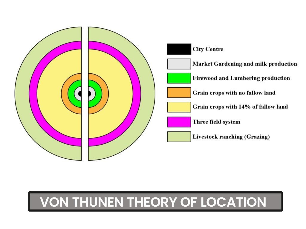
i. Von Thunen and his theory of location: Von Thunen was a German farmer and economist who came up with a theory to explain why different types of farms are located where they are. Von Thunen was a German economist who developed a theory to explain how farmers decide where to locate their farms. He suggested that the location of farms is determined by the costs of transportation to market and the prices farmers can get for their goods. According to his theory, farms that produce perishable or heavy goods are located closer to the market to minimize transportation costs, while farms that produce less perishable or lighter goods are located farther away. This theory helps us understand the spatial patterns of agricultural land use and why different types of farming are found in different areas.

Walter Christaller's Central place theory

ii. Walter Christaller’s Central place theory: Walter Christaller was a German geographer who developed the Central Place Theory to explain the arrangement and hierarchy of human settlements. He suggested that towns and cities are like centers of activity that provide goods and services to surrounding areas. According to his theory, larger cities serve as central places that offer a wider range of goods and services, while smaller towns provide more basic needs. These settlements are organized in a hierarchical order, with larger cities at the top serving larger areas and smaller towns nested within them, each serving smaller areas. Christaller’s theory helps us understand how settlements are structured and interconnected based on the distribution of resources and the needs of the population.

Theories and principles of settlements

iii. August Losch theory of Economic Landscape: August Lösch, a German economist, developed the theory of economic landscapes, also known as the Löschian model, in his seminal work “The Economics of Location” (1940). Lösch’s theory seeks to explain how economic activities are spatially distributed within a region based on factors such as transportation costs, market demand, and production costs.

This theory states that economic activities within a region are spatially organized based on minimizing costs and maximizing profits. This theory emphasizes the role of transportation costs, market demand, and production costs in determining the location of firms and settlements. It introduces concepts such as bid-rent curves and isotropic surfaces to illustrate how firms optimize their location choices to achieve economic efficiency within a given spatial context.

Weber's least-cost location analysis

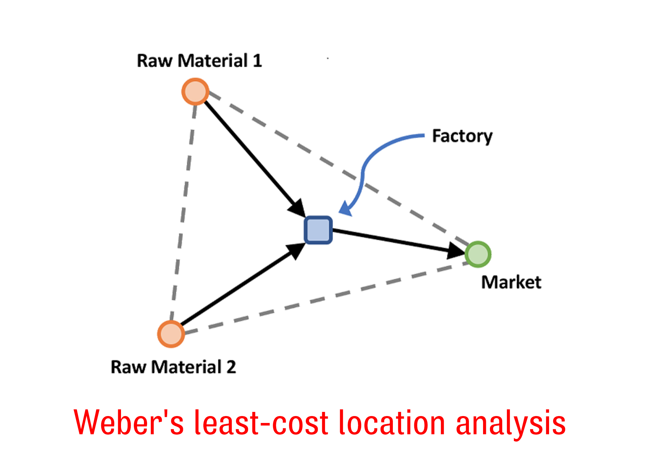
iv. Webber and his least-cost location analysis: Weber’s least-cost location analysis, also known as Weber’s model or Weber’s theory of industrial location, is a the, a German economist, in 1909. This model seeks to determine the optimal location for an industrial facility based on minimizing transportation costs.

Walter Christaller's Central place theory - Theories and principles of settlements

Weber’s model makes several key assumptions:

  1. Homogeneous resources: Resources, including raw materials and labor, are uniform across the region.
  2. Single product: The facility produces a single product.
  3. Perfect competition: There are perfect competition and constant returns to scale.
  4. Fixed input-output coefficients: The input-output ratios remain constant.

The model is based on the idea that the location of an industrial facility should minimize the total costs of production, including transportation costs for inputs and outputs. It considers the location of raw material sources, the location of the market for the finished product, and transportation costs between these locations.

Weber’s model is represented mathematically as:
Total Cost = a * Distance to Raw Materials + b * Distance to Market

Where:

  • a and b are the weightings or coefficients representing the relative importance of transportation costs for raw materials and the finished product, respectively.
  • Distance to Raw Materials is the distance from the proposed location to the sources of raw materials.
  • Distance to Market is the distance from the proposed location to the market for the finished product.

The least-cost location is determined by finding the location that minimizes the total cost of production. This analysis helps businesses make informed decisions about where to locate their facilities to optimize their competitiveness and profitability.

In conclusion, understanding the theories and principles of settlements provides invaluable insights into how human societies interact with their environments and shape their habitats. From ancient civilizations to modern urban landscapes, these theories illuminate the intricate dynamics of settlement formation, development, and sustainability. By delving into concepts such as urbanization, site selection, and spatial organization, we gain a deeper appreciation for the complexities of human geography. As we navigate the ever-evolving landscapes of our world, the knowledge gleaned from studying settlements equips us with the tools to plan, adapt, and thrive in our built environments while preserving the natural world around us.

Introduction to settlement geography

Introduction to Settlement Geography

What is settlement geography?

Settlement Geography is a branch of human geography that studies or investigates the earth’s surface part where humans settle. The primary aim of studying settlement geography is to acquaint with the spatial and cultural characteristics of human settlement under varied environmental conditions.

What is Human Settlement

According to the United Nations Vancouver Declaration on Human Settlement (1976), human settlement is the totality of the human community, whether city, town, or village, with all the social, material, organizational, spiritual, and cultural elements that sustain it.

A human settlement can also be defined as an existence of occupancy for shelter, where people live. It is man’s structural transformation towards application to his environment. A settlement is man’s first step towards adaptation to his environment.

Settlement designates an organized colony of human beings together with their residences and other buildings (like shops, hotels, banks, schools, markets, etc), roads, and streets, which are used for travel. Settlements are located as advantageously as possible with respect to natural features such as water, fuel, food, protection, and drainage as well as access to transportation and communication.

Importance of Settlement Geography

The study of settlement geography is essential to understanding the complex interactions that exist between human populations and their environment. This section explains the relevance of settlement geography and how it affects various aspects of our lives.

  1. Understanding Human Behavior: Studying settlement geography helps us to understand how people choose and organize their living spaces. It investigates the reasons behind the formation of communities, cities, and rural areas, providing insights into the dynamics of human behaviour and activities within these spaces.
  2. Effective Urban and Rural Planning: Settlement geography is crucial for planners to design and allocate resources efficiently. By analyzing settlement patterns, urban planners can develop infrastructure that aligns with the specific needs of certain communities, thereby contributing to sustainable and well-organized urban and rural areas.
  3. Cultural Preservation: Settlements embody cultural practices and traditions, influencing their spatial organization. The study of settlement geography allows us to recognize and preserve the historical and cultural significance of different areas, ensuring the transmission of societal values through generations.
  4. Economic Development: The field helps identify key locations for economic activities, such as trade hubs and industrial zones. Understanding settlement geography aids in optimizing land use, balancing economic development with environmental considerations, and fostering regional growth.
  5. Historical Insights: Settlement geography traces the historical evolution of human habitats. By studying past settlement patterns, we gain valuable insights into the development of societies, the impact of technological advancements, and the preservation of historical landmarks.
  6. Demographic Studies: The analysis of population distribution and movement within settlements provides crucial information for policymakers. It helps policymakers, and other government bodies to anticipate demographic changes, plan for social services, and make informed decisions regarding infrastructure and allocation of resources.
  7. Addressing Contemporary Challenges: Settlement geography helps in tackling modern challenges like urban sprawl, congestion, and inadequate housing. It provides a foundation for developing strategies for sustainable and smart cities, ensuring that our habitats evolve to meet the changing needs of the population.

A Brief Overview of the Historical Perspectives of Human Settlement

1. Nomadic Lifestyles and Early Settlements: In the early stages of human history, nomadic lifestyles characterized by constant movement in search of food and resources were prevalent. As communities transitioned from hunting and gathering to agriculture, settled agricultural communities emerged. This shift marked a crucial moment in the development of human settlements, as people began to establish permanent homes and cultivate the land.

One notable example of the nomadic lifestyles and early settlements is the Sumerians, who inhabited the region of Mesopotamia (modern-day Iraq) around 4500 BCE. The Sumerians are often considered one of the world’s earliest civilizations and were pioneers in agriculture, developing advanced irrigation techniques to harness the fertile soil between the Tigris and Euphrates rivers.

2. Ancient Civilizations – Mesopotamia, Egypt, and the Indus Valley: Ancient civilizations like Mesopotamia, Egypt, and the Indus Valley witnessed the establishment of organized urban centers. These settlements were strategically located near fertile river valleys, allowing for agricultural prosperity. The construction of cities with complex infrastructures, such as the ziggurats of Mesopotamia and the pyramids of Egypt, showcased advanced engineering and societal organization, setting the stage for the growth of urbanized societies.

3. Medieval and Renaissance Periods – Feudal Settlements and Market Towns: During the medieval period, feudal settlements became prominent, characterized by the hierarchical structure of feudalism. Lords, peasants, and artisans formed a tightly knit community around a central castle or manor. The Renaissance period witnessed the rise of market towns as trade routes expanded. These towns became economic hubs, fostering trade, commerce, and the exchange of ideas, laying the groundwork for the development of modern cities.

4. Industrial Revolution and Urbanization: The Industrial Revolution marked a pivotal moment with the shift from agrarian economies to industrialization. This period saw the rapid growth of cities as people migrated from rural areas to urban centers in search of employment in factories. The emergence of industrialized urban landscapes transformed the social, economic, and spatial dynamics of settlements, leading to increased population density and the creation of urban infrastructure.

Factors Influencing Settlement Patterns

The way in which communities organize and inhabit their spaces are influenced by a combination of physical geography and human factors.
A. Physical Geography:

  1. Topography: The shape and features of the land, like mountains or plains, impact where settlements develop.
  2. Climate and Weather: Weather conditions, including temperature and precipitation, influence the types of settlements that thrive in specific regions.
  3. Soil and Natural Resources: The quality of soil and the availability of resources like water and minerals affect settlement locations and sustainability.

B. Human Factors:

  1. Demographics: The composition and distribution of the population play a role in shaping settlement patterns, and determining factors such as the size and layout of communities.
  2. Culture and Traditions: Cultural practices and traditions influence the spatial organization of settlements, from the layout of buildings to the use of public spaces.
  3. Economic Activities: The types of economic activities, such as agriculture or industry, impact settlement locations, and growth, shaping the economic landscape of a region.
Types of settlements - Introduction to Settlement Geography

Types of Settlements

The following are the types of human settlements;

  1. Urban Settlement
  2. Rural Settlements
  1. Urban Settlement: An urban settlement refers to a concentrated and densely populated human habitat that is characterized by a high degree of social, economic, and cultural complexity. Examples: Cities, towns, and metropolises exemplify urban settlements. Urban settlements exist in different forms and sizes. These are discussed below;
    • Town: A town is a medium size human settlement, Towns are usually larger than villages but smaller than cities, though the criteria which constitute them vary considerably in different parts of the world. In some places, a town should have at least 5000 people, 400 person per sq km, and at least 75 % of residents engaged in agriculture
    • City: A City is a large human settlement. Cities usually have extensive systems for housing, transportation, Sanitation, utilities, land use, and Communication. Their densities facilitate interaction between people, government organizations, and businesses, sometimes benefiting different parties in the process.
    • Metropolis: A Metropolis or Comerbation is a large city that is a significant economic, political, and cultural Center for a country or region, and an important hub for regional or international Connections, Commerce, and Communications. The term is ancient Greek and means the ” Mother City ” of a Colony, the city that Send Out Settlers. At least with a minimum population of One to three million.
    • Megalopolis: A Megalopolis, megaregion, or supercity is defined as a chain of roughly adjacent Metropolitan Areas that may be somewhat separated or may merge into a continuous Urban region. The term was first used by Patrick Geddes in his 1915 book – Cities in Evolutions. It was derived from the Greek – words – Megas meaning great and polis meaning city. Therefore literally a great City. The term has a closer meaning to megacity. A megalopolis also known mega-region is a clustered network of cities. The population of mega-regions ranges from 10 – over 250 million.
    • Primate City: A Primate City is the largest area in its country or region, which is disproportionately larger Other cities in the Urban hierarchy. It is derived from a Latin word – Prime meaning first in rank and was first proposed by Mark Jefferson in 1939. He defines a Primate city as being at least twice as large as the next largest city and more than twice as significant, Among the best-known primate cities in the world are London and Paris. Other major primate cities include Athens, Baghdad, Bangkok, Budapest, Buenos, Aires, Cairo, Dublin, Jakarta, Kuala Lumpur, lima, Mexico City, Seoul, Tehran, and Vienna, etc.
  2. Rural Settlement: A rural settlement refers to a community or cluster of dwellings located in non-urban or countryside areas typically characterized by lower population density and a predominant focus on agricultural activities, rural settlements showcase a more dispersed arrangement of homes and structures across the landscape. Rural Settlement types include hamlet, Village, and urban,
    • Hamlet: Hamlet is a small human settlement, In British geography a hamlet is considered Smaller than a Village and distinct, without a church. Officially a hamlet differs from a village in having no commercial premises, but has residences and may have community buildings such as Churches and public halls.
    • Village: A village is a clustered human settlement or community larger than a hamlet but smaller than a town with a population ranging from a few hundred to a few thousand. In the past, villages were a usual form of community for societies that practice subsistence agriculture and also for some non – agricultural societies.
    • Rurban/Suburban: Rurban or Suburban is a transitional phase between rural and urban settlements. It is the point where rural and urban environments interact and where there exist both rural and urban lifestyles. It is where urban and rural land uses are mixed.

Function of settlements

rural areas basically have the majority of their populations involved in primary functions (i.e. fishing, farming, lumbering, etc.) whereas in urban areas people have secondary (manufacturing, construction, etc) and tertiary functions(services) as the major occupation.

Five major criteria are used to differentiate between rural and urban areas. These criteria are outlined below ;

  1. Morphology: Here, the urban structures are marked by tall buildings, wide roads, and administrative and recreational centers in contrast to rural settlements which are usually agrarian landscapes.
  2. Demography (high or low population density): Urban areas are marked by high population density and compact settlements in comparison to rural areas where population density is relatively low
  3. Cultural Traits: The urban areas are marked by class stratification in contrast to the rural areas where caste and religious stratification is more prominent. Urban settlements are heterogeneous culturally, whereas rural settlements are heterogeneous culturally.
  4. Economic Infrastructure: These include transportation, communication, and marketing infrastructure. These are more developed in urban and rural areas.
  5. Social Infrasture: These include health, education, recreation, etc. Infrastructure where urban areas score higher than rural areas.

Methods OF Studying Settlement Geography

In Studying a subject for the first time, it is better to begin by obtaining an Overview of the conceptual framework, themes, and issues relating to the field. Each subject has a need for Systematic rules, Methods, Techniques, and Systems for appropriate and Systematic Study. These methodologies are known as approaches.

Hartshorne recognized two approaches to the study of Settlement geography- Systematic and regional approaches while Dickinson expresses settlement geography in terms of structure, Process, and stage. There are three important approaches to settlement geography. These are

(1.) Genetic approach

(2.) Spatial/ Regional Approach

(3.) Ecological Environmental Approach

(1.) Genetic Approach: This approach.

(i.) Works on the basis of historical processes

(ii.) is supported and influenced by historical perspective, archaeological and geographical facts are commonly applied in the study.

(iii.) Proper investigation of documents, places, names, etc.

(iv.) Comprehensive understanding of individual characteristics in relation to the Surrounding Subsystems.

(v.) Deals with a genetic progression that is past, present, and future of the settlement. There are three approaches here;

(a.) Retrogressive: This focuses on or upon the past evidence and is also a concern with the present pattern of settlement.

(b.) Retrospective: This focuses upon the present, the past conditions regarding settlements being considered for a better understanding Of the existing state.

(c.) Prospective: This is not only concerned with the future but the past and present are considered as a relict.

2. Spatial Regional Approach: This approach was introduced by Ratzel. It basically relates to patterns and Processes by considering the man-environmental relationship. The approach has Systems and subsystems and involves the analysis of the various aspects of settlement like types, patterns, classification functional integration and rank, local identity, planning and rationalization, site, and situation. This approach uses several techniques such as nearest neighbor analysis, Method of dispersion concentration, land model, functional analysis method, etc to study settlements.

3. Ecological/ Environmental Approach: This approach Studies Environmental adaptation in a region. It explores the whole range of human activities and their impact on the urban environment. It focuses on the processes of change in human behaviour and settlement over time.

Introduction to Economic Geography

What is Economic Geography?

Economic geography is a branch of human geography that studies the spatial distribution of economic activities, as well as their relationship interactions with the physical and social environments. It examines the relationship between geographic location, regional economies, and economic processes like production, consumption, trade, and investment.

It is concerned with the ways and problems of making a living and spatial interaction, it is concerned with the exploitation of the earth’s natural resources, the production of commodities, whether raw materials, foodstuffs, or manufactured goods, and their transportation, distribution, and consumption.

BRANCHES OF ECONOMIC GEOGRAPHY

Branches of Economic Geography

Economic geography is a broad field and therefore divided into several branches or sub-categories to focus on different aspects and dimensions of economic activities and their spatial patterns. The following are the key branches of economic geography;

  1. Industrial Geography: This field investigates the geographical organization of economic activity in urban areas, as well as the growth of industrial sectors. It studies the placement and clustering of industrial facilities in urban areas, urban economic structures, land use patterns, urbanization processes, and the effects of urbanization on economic development.
  2. Geography of International Trade: This focuses on the flows, spatial patterns, and relationships of international trade activities between countries and regions. It examines the geographical aspects of trade, including the trade routes, locations of export and import activities, and the distribution of traded goods and services.
  3. Agricultural Geography: This is a branch of economic geography that is concerned with the spatial distribution, features, and interactions of agricultural systems and activities. It investigates how environmental, social, economic, and political factors influence agricultural practices, land use patterns, and food and other agricultural product production.
  4. Transportation and Communication Geography: This branch of economic geography places its focus on the spatial patterns and relationships of transportation networks and communication infrastructure. It examines how these systems shape the movement of people, goods, services, and information across different regions and how geography influences the development and organization of transportation and communication networks.
  5. Geography of resources: This is a branch of economic geography that studies the distribution and features of resources that distinguish one region from another, with a focus on resource consumption, evaluation, conservation, and management in relation to the environment. It includes a study of man’s demand for natural resources, as well as their exploitation and development.

HISTORY OF ECONOMIC GEOGRAPHY

History of Economic Geography

Economic geography has evolved and developed over time through various stages, the following are the stages:

  1. Early Foundations (18th–19th century): Economic geography has its roots in the writings of Adam Smith and David Ricardo, two classical economists who discussed the impact of geography on economic activity and international trade. They made emphasis on the role that resources, trade, and comparative advantage play in determining economic trends.
  2. The Quantitative Revolution (1950s-1960s): The 1950s and 1960s saw a change toward a more quantitative and analytical approach to Economic Geography. Scholars focused on modeling economic processes and investigating the spatial distribution of economic activities, driven by advances in spatial analysis and regional science. Understanding location theory, regional growth trends, and industrial placement were all emphasized.
  3. New Economic Geography (1980s-1990s): This emerged due to the influence of factors like economic theory, and the rise of globalization.  Paul Krugman and Michael Porter, among other prominent scholars, studied the causes of economic activity agglomeration and clustering, the function of trade, and the effects of economies of scale and transportation costs on regional development.
  4. Critical and Cultural Turns (late 20th century-present): At this stage, the focus of Economic Geography shifted towards adopting critical and cultural perspectives. Scholars began to investigate economic processes’, social, political, and cultural components, delving into topics like gender, labor, globalization, unequal development, and environmental sustainability. This transition gave rise to subfields such as feminist economic geography, cultural economy, and political economy.
  5. Spatial Analysis and GIS (late 20th century-present): Economic geography went through a revolution with the introduction of Geographic Information Systems (GIS) and spatial analysis methods. Researchers started analyzing economic processes at various scales using geospatial data, mapping, and spatial modeling. A greater knowledge of spatial patterns, accessibility, and the effects of policy interventions was made possible by the incorporation of spatial analysis techniques.
  6. Contemporary Approaches: Today’s economic geography covers a diverse range of approaches and topics. Regional development, urban and rural economies, international production networks, innovation and knowledge economies, sustainability, and the digital economy are just a few of the topics it explores. Collaborations between economic geography and other academic disciplines like sociology, anthropology, and environmental studies have helped in the improvement of the discipline.

In response to continual economic, social, and environmental changes, economic geography continues to grow and evolve. Today’s emphasis in the field is to understand the complexity of international economic systems, solve social and environmental injustices, and advance inclusive and sustainable economic growth.

Contributions of key figures in the history of Economic Geography

Contributions of key figures in the history of Economic Geography

Throughout history, various prominent personalities have shaped the field of economic geography. The followings are Some important contributors and their substantial contributions to the growth of economic geography;

  1. Johann Heinrich von Thünen (1783-1850): Thünen was a German economist who laid the foundation for spatial economics and agricultural land use theory. His work, particularly “The Isolated State” (1826), introduced the concept of the “von Thünen rings” to explain the spatial organization of agricultural activities around a central marketplace.
  2. Alfred Weber (1868-1958): German economist Weber is renowned for his contributions to the theory of industrial location. He popularized the idea of the least-cost location in his book “Theory of the Location of Industries” (1909), which focused on labor, transportation costs, and agglomeration economies as major determinants of the geographic distribution of industries.
  3. Walter Christaller (1893-1969): In 1933, a German geographer by the name Walter Christaller, developed the central place theory in his book “Central Places in Southern Germany”. this theory examines the size, number, and spacing of urban settlements based on the provision of goods and services to surrounding areas. This theory has contributed to our understanding of the organization of cities based on hierarchy and their functional relationships.
  4. August Lösch (1906-1945): In 1940, a German economist and geographer by the name Lösch, expanded further on Weber’s industrial location theory and introduced the concept of “satisficing” behavior in his book “The Economics of Location”. August Losch argued that firms and businesses only aimed at satisfaction rather than a suitable location for the company, considering factors beyond cost like market potential and competition.
  5. Brian Berry (1934-2002): An American geographer, Berry made substantial contributions to the fields of spatial analysis and regional development theory. He contributed to the development of quantitative approaches in economic geography through his work on location-allocation models and spatial analysis techniques, including the gravity model and spatial interaction models.
  6. Paul Krugman (1953-present): The work of American economist Krugman, who focuses on trade and economic integration, has significantly influenced the study of economic geography. The research he conducted on the “New Economic Geography” contributed to the understanding of the spatial concentration of economic activities as well as the significance of increasing returns to scale and transportation costs.
  7. Doreen Massey (1944-2016): British geographer by name Massey, significantly influenced our understanding of spatial and social relations in economic geography. Her work questioned conventional ideas of space and place by focusing on the social creation of places and the interactions between power, identity, and economic processes.

These notable people have significantly influenced the growth of economic geography by offering conceptual frameworks, analytical methods, and empirical findings that have altered the discipline’s understanding of spatial economic processes. Their work still has an impact on current economic geography studies.

Approaches of Economic Geography

Economic geography is a very broad discipline, and economic geographers all over the world employ a variety of methodologies. The following are some of the distinct approaches to economic geography that have evolved over time;

  1. Theoretical economic geography: This focuses on building theories about the spatial arrangement and the distribution of economic activities. It seeks to answer fundamental questions about why economic activities are unevenly distributed across space and how this uneven distribution influences economic outcomes.
  2. Regional economic geography: This investigates the economic conditions of specific regions or countries around the world. It addresses both economic regionalization and local economic development. It looks into the factors that contribute to regional disparities and uneven development.
  3. Historical economic geography: It examines the historical processes and events that have shaped the spatial patterns of economic activities. It investigates how historical factors, such as colonization, industrialization, and technological advancements, have influenced the development and organization of economies. By understanding the historical context, this approach helps explain the long-term dynamics and legacies that contribute to the current economic geography of regions. It uses historical data to examine how regional centers of population and economic activity change over time, how patterns of regional specialization and localization change, and what causes these changes.
  4. Critical economic geography: This is an approach that evaluates the political, social, and political dynamics that underlie both spatial and economic activities. It examines how capitalism, globalization, and neoliberal policies affect economic geography while criticizing conventional economic theories. It places a strong emphasis on social justice, inequality, and environmental sustainability while criticizing dominant power structures and promoting radical change in the way that economic systems and physical space are organized. This approach is derived from the perspective of contemporary critical geography and it’s philosophy.
  5. Behavioral economic geography: This examines how human behavior and decision-making processes influence economic activities and spatial patterns. It studies how individuals, organizations, and institutions make decisions, interact with one another, and respond to incentives in specific geographical situations. This approach incorporates behavioral economics principles into the study of economic geography in order to give an insight into the psychological, social, and cognitive aspects that influence economic behavior at the individual and organizational levels.

Importance of the Study of Economic Geography

The study of Economic geography is important for a variety of reasons, including:

  1. Understanding Spatial Patterns: Understanding the spatial distribution of economic activity, such as industries, trade flows, and urban centers, is made easier by studying economic geography. It explores the reasons behind why certain economic activities are concentrated in particular areas or nations, as well as how resources, transportation systems, and market access influence these patterns. For decision-makers, companies, and researchers to make well-informed choices about regional growth, investment, and trade policies.
  2. Regional Development and Planning: Economic geography sheds light on regional development discrepancies as well as measures for encouraging balanced growth. It helps identify the strengths and weaknesses of distinct regions by assessing aspects such as agglomeration economies, infrastructure development, and human capital.
    This knowledge can assist policymakers in developing successful regional development policies, promoting economic diversification, and minimizing regional inequities.
  3. Globalization and Trade: Understanding the dynamics of globalization and international trade requires a thorough understanding of economic geography. It looks at the spatial patterns of supply chains, trade flows, and global industrial networks. It aids in identifying factors influencing where manufacturing takes place, the function of transportation networks, and the effects of trade policy on local economies. For governments, companies, and economists looking to navigate the complexity of global commerce and maximize economic potential, this understanding is crucial.
  4. Urban and Regional Planning: Economic geography is used by urban and regional planners to evaluate the spatial organization of cities and regions. It can be used to investigate aspects like land use, transportation networks, and access to services and amenities. Urban planners can use this knowledge to create cities that are sustainable, enhance infrastructure, and encourage effective land use. In order to understand the spatial dynamics of urbanization, including issues like suburbanization, gentrification, and urban sprawl, economic geography is also helpful.
  5. Environmental Impacts: The interaction between economic activities and the environment is examined in economic geography. It examines how natural resources are distributed geographically, how human activity affects ecosystems, and how sustainability plays a part in regional development. Economic geography offers frameworks for promoting sustainable resource use and reducing environmental risks, as well as insights into how economic systems interact with natural systems.
  6. Policy Formulation: For evidence-based policy development, economic geography offers a strong foundation. Policymakers can use economic geography studies to pinpoint industries for development, identify regional assets, and create efficient policies to support economic growth and resilience. Additionally, economic geography aids in understanding the geographical effects of policy interventions, assessing the success of regional development programs, and foreseeing the consequences of economic shocks or disruptions.

Conclusion

In conclusion, economic geography is a broad and multidisciplinary topic that explores the complex relationship between economy and space. We acquire significant insights into the dynamics of our economies and the causes that shape them by digging into the geographical structure of economic activities, examining theoretical frameworks, and investigating real-world case studies. Economic geography, through its practical applications and policy implications, helps to create a more informed and resilient economic environment, assuring a sustainable and prosperous future.

Introduction to population geography

Beyond the Numbers: Understanding the Human Story of Population Geography

Definition of population Geography

Population geography is a branch of human geography that is concerned with the study of the spatial distribution of the human population over the surface of the earth over time, its patterns (in terms of their numbers, performances, and their settlements), with reference to their physical and cultural environment.

It is important to study population geography, so as to understand how human populations interact with their immediate environment, how they influence and are influenced by factors like economic, political, and social factors, and also how humans influence the regional and global patterns of development and change.

Historical development of population geography

Historical Development of population Geography

Over time, the field of population geography has advanced, adopting modified theories, methods, and data sources. The historical development of population geography can be traced from the 18th century to the mid-20th century. Below are the following theories that have contributed to the historical development of population geography, they are;

Malthusian Theory of Population (1798)

1. Malthusian Theory (1798): In the 18th century, in man’s quest to understand the relationship between population and resource availability, various authorities, researchers, scientist, etc. have proposed their theories concerning the relationship and the consequences of an increasing and uncontrolled population growth.

One of these notable theorists was Thomas Robert Malthus. Thomas Malthus was a popular British economist, who in 1798 made a publication of his famous book “An Essays on the principle of population”. Thomas Malthus warned against uncontrolled population growth, in the face of limited food availability which can lead to famine, disease, and crisis.

He stated that, while population increases in geometric terms or patterns (i.e. 1, 2, 4, 6, 8), food production on the other hand increases in an arithmetic pattern (i.e. 1, 2, 3, 4, 5, 6). Thomas Malthus proposed that the only way to prevent this crisis was through what he called “Preventive Checks” and “Positive Checks”.

MALTHUS PREVENTIVE CHECKS

According to Robert Malthus, humanity should be compelled to take certain steps and make sacrifices that can ensure a sustainable era of population growth without starting a crisis. The following are the preventive checks that Robert Malthus Proposed;

  • Delays in marriages
  • Birth Control
  • Policies to discourage mass production of children.

MALTHUS POSITIVE CHECKS

The following are the preventive checks that Robert Malthus Proposed;

  • Environmental disasters
  • Poverty
  • War
  • Famine

CRITICISM OF MALTHUSIAN THEORY

CRITICISM OF MALTHUSIAN THEORY
  1. Critics have it that, at the time of his writings and publications, the capacity of the world and policymakers to generate data was quite low and inaccurate. Therefore, Mathus Publications are not backed up with accurate data.
  2. Malthus’s theory has very well been faulted as science, inventions, innovation, discoveries, involvement in the use of technology, improvement in medical science, and the elimination of diseases like measles, smallpox, and chickenpox that affected mostly children at young ages, etc. gradually emerged, etc.
  3. Critics have also maintained that apart from feeding from society, humanity is also gifted with the capacity to contribute to the development of society.
  4. Contemporary critics of Malthus’s Theory believe that all that Thomas Malthus said and wrote about in his essay, is not applicable to other continents in the world (especially Asia and Africa) except Europe.
  5. Malthus’s position against early marriages has been opposed by contemporary critics because, for them, it is against biblical injunctions and also an infringement on human freedom.
  6. In the agricultural sector, the coming up of new lands has addressed Thomas Malthus’s adverse position.
  7. The massive improvement and investments in various modes of transportation have in a way faulted Malthus’s Adverse position.

2. Marxian Theory of population growth (1848): The Marxian theory (a.k.a Marxism) was developed by the German philosopher and economist Karl Marx in 1848. The Marxist theory is a political, economic, and social philosophy that focuses on the analysis of capitalist society and the ways in which social inequalities are created and managed in a capitalist society.

This theory of population growth was known as the theory of surplus population. If you read more about Karl Marx’s theory, you will discover that Karl Marx wasn’t a geographer but he gave some ideas about population growth while he was postulating his general theory of communism and scientific interpretation of history in his books like – “The Communist Manifesto (1848)” and “Das Kapital (1867)”.

He didn’t propose any theory of population separately, but his theory of surplus population is deduced from his theory of communism. At the time that he was publishing these books (1848 and 1867), industrialization was heading toward its peak and large-scale industrialization was leading to the capitalistic mode of production in society. He criticized the Malthusian theory of population.

Marxist Population Cycle

Karl Marx had the opposite idea about population growth, for Karl Marx, these social problems were not the fault of the poor workers, but of the capitalist system that exploited them. According to Karl Marx’s population cycle;

  1. Labour class increases its population with the hope of increasing its family income. In poor societies, it is believed that if there are more children, they would grow up and earn more income for the family’s well-being and society’s welfare.
  2. As the population increases, the labour supply market gains more.
  3. The industrial market will keep exploiting the labour class to make more profit, without increasing the wages of the labour class.
  4. The industrial society will acquire more resources leaving behind no resources for the labour class.
  5. The poor get poorer with no increase in their family income.

CRITICS OF MARXIAN POPULATION THEORY

Criticism of Marxian Population Theory

Marxian theory of population has faced a variety of critics despite earning recognition and support from many scholars and researchers, the following are the key critics of the Marxian theory of population;

  • Critics have it that Karl Marx underestimated the capacity of technology in sustaining production to match the rate of population growth.
  • According to feminist scholars, Karl Marx’s theory of population failed to recognize the social construction of gender roles and overlooks the reproductive labour of women.
  • It is believed that Marx’s population theory is very deterministic and therefore fails to give an account of the diversity of historical experiences of population growth and the labour sector.
  • Critics have it that, Karl Marx’s population theory is ignorant of the ecological impact of growth and industrial development.

NATURE OF POPULATION GEOGRAPHY

The following are the nature of population geography;

1. SYSTEMATIC NATURE: The systematic nature of population geography refers to a general or specific aspect of a physical or human phenomenon in a given geographical space that is presented in an orderly manner in accordance with a system of the plan. According to the presidential address of Trewartha in 1953, population geography switched from the regional nature of population geography to the systematic nature of population geography.

Under the systematic nature of population geography, various topics or components of the population in a given area are studied systematically. It is focused on systematically studying population distribution and density, population evolution and composition, resources, population problems, population planning, management, and policies in a specific geographical area.

Therefore, population geography’s systematic nature allows for the creation of generalized theories and formed models.

2. REGIONAL NATURE: Regional geography is the study of all aspects of a certain space or region. This nature emphasizes a specific region. Prior to Trewartha’s introduction of population geography in 1953, population studies were a component of regional geography. Each regional geography invariably included a chapter on population while explaining the elements of regional character. Take Nigeria, for example, the country is divided into several tiny areal units called regions, and such areas may be delineated by the homogeneity of physical, political, cultural, or demographic factors.

3. DYNAMIC NATURE: Population geography is particularly dynamic in nature because various modern issues are constantly being incorporated into its surroundings. The population’s size, growth, and age distribution are examined in light of its dynamic nature. Additionally included are the rates of birth, death, immigration, and emigration.

For instance, Lagos, one of the cities with the fastest population growth worldwide, has seen a significant rise in its population because people from other states within Nigeria migrate there for better economic opportunities like Job employment, education, lucrative skills, getting more business clients, etc.

4. ECOCENTRIC NATURE: The existing natural resources are under more stress as the population grows. The scarcity of resources, desperate use of resources, disregard for natural laws and principles, and other factors have all contributed to some issues with human life. What should be our method of interaction, the best way to use resources without endangering nature, etc. should also be placed as a priority in population geography.

Population geography is by its very nature a vast synthesis of various demographic dynamics. the main components of population studies, which are extremely dynamic in nature. Because of this, a variety of detailed descriptions, from ecological ethics to demographic aspects, have been expressed genetically in different sections of the study.

5. MULTIDISCIPLINARY NATURE: Population Geography is multidisciplinary in nature as it is not solely the domain of any social science. Except for geography, demography, sociology, anthropology, economics, mathematics, and social sciences, history plays a vital role in making significant contributions to understanding various aspects of the population.

For example, population geography uses demographic analysis to examine population patterns and trends across various geographic areas and historical eras. Also, To understand the social and cultural factors that influence population growth and distribution, such as migration patterns and fertility rates, population geography draws on sociology.

population geography is multidisciplinary in nature because it draws on different fields of study to examine population patterns and processes, including social, cultural, economic, and geographic factors.

6. HUMANISTIC NATURE: Population geography being humanistic in nature means that it involves more than just quantitative statistical techniques to explain the causes, effects, and outcomes of population patterns. It also encompasses qualitative categories of human geography such as cultural geography, political geography, social geography, and urban geography.

Its focus is on enhancing human skills, and knowledge, and modifying their behaviour to produce well-equipped and enriched citizens who can contribute positively to society.

In addition, population geography, with its humanistic approach, addresses a range of value-oriented problems, such as child and women exploitation, slavery, labour force, uneven consumption, and malnutrition. By understanding the underlying social, cultural, economic, and political factors that contribute to these problems, population geographers can suggest strategies and interventions for addressing them.

DEMOGRAPHY AND POPULATION GEOGRAPHY, WHAT’S THE DIFFERENCE?

Demography and population geography are two disciplines or fields that are popularly known to deal with the study of human populations. But let us not mix them up, while they share some similarities, they are different in their approaches and focus. Let’s take a look at the key differences between demography and population geography below;

Demography is the discipline that deals with the study of the characteristics of human populations like distribution, size, dynamics, and composition. Demography is also focused on factors such as birth and death rates, human migration patterns, and the social and economic factors that influence growth and change in the human population. It uses statistical analysis and mathematical models to describe and predict population trends.

On the other hand, population geography is a branch of human geography that focuses mostly on spatial patterns, distribution and processes of the human population. It studies the interactions between humans and their physical and cultural environments, including issues such as rural-urban migration, urbanization, population density, and spatial inequalities. Population geography is concerned with the distribution of populations across space, and how these distribution patterns change over time.

With the following points listed above, we can be convinced that though demography and population geography have similarities, they are not the same thing.

POPULATION GEOGRAPHY IN THE CONTEXT OF WORLD POPULATION

Population geography sheds light on how people are distributed across various geographical areas, how they change over time, and how these changes affect societies and the environment in the context of the world’s population.

The following are some key aspects of population geography in the context of world population:

i. Population Distribution: Population geography studies how people are distributed around the world. It examines the determinants of where people choose to reside, including climate, topography, resource accessibility, economic opportunities, and historical and cultural aspects. It also looks at variations in population density (the number of people per unit of area).

ii. Population Growth and Decline: Population geography studies population changes over time, such as population growth and decline. It looks into birth rates, death rates, migration patterns, and other demographic factors that influence population growth or decline in various parts of the world.

iii. Urbanization: Urbanization is the process of the growth and expansion of cities, and it is one of the topics explored by population geography. It looks at the push and pull factors that influence migration from rural to urban areas, the expansion of megacities, and the difficulties brought on by accelerated urban development.

iv. Migration: Population geography places a lot of emphasis on migration. It looks into both internal and external migration within nations as well as people moving across borders. The study of population geography examines the driving forces behind migration, including monetary incentives, social and political dynamics, and environmental factors. Additionally, it looks at how migration affects both sending and receiving regions.

v. Population aging: The increase in the proportion of older people in a population, is a demographic phenomenon that population geography addresses. It examines the factors that contribute to population aging and its effects, as well as the social, economic, and healthcare repercussions for nations and areas with aging populations.

vi. Demographic Transition: A key idea in population geography is the demographic transition theory. It discusses how social and economic advancement caused historical shifts in birth and death rates from high to low. Population geography examines how different regions are positioned within this demographic transition and the implications for population growth and structure.

In conclusion, Population Geography is an important field of study that investigates the distribution, growth, and characteristics of populations all over the world. Population Geography provides valuable insights into the dynamics and challenges of human populations by analyzing demographic indicators such as birth rates, death rates, migration patterns, and population density.

To address issues like urbanization, migration, and sustainable development, population geography research and understanding must continue. With the knowledge of population geography, Policymakers, urban planners, and social scientists can create resilient and inclusive societies by analyzing and forecasting population trends.

Introduction to Human Geography

Discovering the Fascinating World of Human Geography: An Inspiring Introduction

What is human geography?

Human geography can be defined as the study of how places are made by people, how space and society are organized, how people interact within their place and across space, and how people make sense of others and themselves in their locality, region, and the world. It uses a combination of spatial, social, and physical science to illustrate a complex story of the world. This complex story is focused on the spatial patterns of people and how we have affected the physical environment that we inhabit, explore, and create by giving these places names.

As human geographers, we try to answer questions that pay special attention to the way people, power, and many buildings are distributed in the world, and what processes that shape where humans move across space, we also focus on why humans build, create, and consume where they do, why these traits change across the space. Why all people and all places are not the same?

Human geography is a discipline with a broad range that puts together many of the strands important for understanding the world that we live in today. It examines human societies and how they develop, it also studies their culture, their economy, their politics, and all within the context of their environment.

Branches of human geography

BRANCHES OF HUMAN GEOGRAPHY

Branches of human geography include;

  1. Population geography
  2. Urban geography
  3. Social geography
  4. Economic geography
  5. Behavioural geography
  6. Cultural geography
  7. Political geography

  1. Population geography: This is a branch of human geography that is concerned with the illustration of how spatial variation in population and its various attributes like migration, composition, and growth.
  2. Urban geography: This has to do with the study of cities and urban processes. It studies the way humans build cities and the relationship between rural and urban areas.                                                                                                                                                                                                            
  3. Social geography: This refers to the sub-category of human geography that studies the relationship between our society and space. What came to your mind when you heard the word “Social Geography”?, let me guess, “Sociology right? Well, you are quite correct if you thought sociology and social geography were interrelated, as they deal with the relation of social phenomena and their spatial components.
  4. Economic geography: This is the branch of human geography that studies the economic activities of places, and the factors that affect them (which could be positive or negative). It is concerned with how people of a particular place earn a living and the variety of livelihood systems across a space or a region.                                                                                         
  5. Behavioural geography: This has to do with the study of human behavior in a specific location or area. It studies human behaviours in a space individually rather than using a broader overview.  It also studies and analyses how different factors affect human behavior. For example, a behavioural geographer can conduct a research to understand how people make decisions about where they can shop for their groceries, and with the results gotten from this research, businesses can come up with better solutions to meet the demands and the preferences of local shoppers in that area.                  
  6. Cultural geography: This deals with the study of how our beliefs, culture, values, and traditions shape the spatial distribution of our societies and our interactions with our immediate environment. It is interested in understanding how our cultural practices affect our landscape and how our landscape also affects our cultural identity.
  7. Political geography: This is a branch of human geography that studies the way political powers and influence shapes the landscape. This deals with boundaries, and subdivisions of a political unit.

How does human geography affect us?

The features that affect us include; vegetation, climate, landforms, and the water cycle. Except from determining whether humans can live in a certain area or not, Human geography determines our lifestyle, and how we adapt to the available food and climate patterns (this means that wherever you live, you going to adapt to where and how you live in a certain area or not, Human geography determines our lifestyle, and how we adapt to the available food and climate patterns (this means that wherever you live, you going to adapt to where and how you live.

Applications of human geography in our daily lives

Human geography has numerous range of applications in our daily lives, below are 5examples of the application of human geography;

  1. Business and Marketing: As it is said in a popular quote “One man’s meat is another man’s poison ”, this means that humans’ preferences and needs differ across space, and regions. Therefore, with the use of human geography, consumers’ behaviours and preferences can be studied and understood, thereby creating opportunities for businesses to meet the demands of their customers, and also generate effective strategies to target their potential customers.
  2. Environmental management: When it comes to understanding the relationship between people and their environment, Human geography has a role to play by studying the impact of human activities on the environment like mining, fishing, logging, etc., and with these studies, human geographers can develop policies and healthy practices that can reduce the negative impact of human activities on the environment.
  3. Urban Planning: With the knowledge of human culture, behaviours, and environment derived from the study of human geography, we can develop cities that are functional and sustainable.
  4. Public Policies: With human geography, we can derive insights into the social and economic challenges that communities face and help in informing public policy decisions.
  5. Tourism: Tourists can understand better and appreciate the cultural diversity of the places that they visit by studying human geography.

Conclusion

In conclusion, physical geography helps us in learning more about economics, technology, language, culture, tradition, religion, and power, and how they all influence our environment.

What is geography? - SimplyGeography

What is Geography?


What is Geography in simple words?

The word “Geography” was gotten from two Greek words which are: “Geo” which means earth and “Graph”  which means to describe. So, putting those two greek words “Geo” and “Graph” together, Geography can simply be defined by a layman as the description of the earth.

The full definition of Geography

However, there’s more to Geography than a mere description of the earth. Hence, can be defined as the study of physical features, places, people, and their activities within the earth.

It also deals with the study of various people in different parts of the earth including their activities like mining, construction, agriculture, trading, fishing, etc, and how these activities affect the earth.

 
Scope of geography

Scope of Geography

Geography is a social science course in the academic world that has to do with the study of man and his activities in the environment.

Therefore, Geography ideas are realistic, practical, and easy to understand because they are very relevant to our daily life experiences.

Geography is also related to many other disciplines such as Economics, Agricultural Science, Biology, Sociology, History, Government, Political Science, Environmental Science, and list goes on. Geography has one or two things in common with all these disciplines as mentioned above.

Brief History of Geography and its branches

Brief History of Geography and its branches

Modern-day Geography originated from medieval Cosmographya fascinating combination of astronomy, astrology, nautical science, earth core, natural history, and history, etc. Gradually as a result of the development of signs and scientific study in the 17th and 18th centuries, cosmography shed many of its facets which became sciences of their own right, examples of these facets were Astronomy, Geology, Meteorology, botany, zoology, etc. The remaining that was left became Geography which was a study focusing mainly on the motions of the earth, its measurements, the description of places, etc.
In the 19th century, Geography was typified by its “capes, coves, and items”, which was a methodology that was somewhat dull and sterile. The tumult of causes in scientific circles by Charles Darwin‘s idea of evolutionary development joined with the tremendous fund of knowledge being made available at man’s disposal as a result of the 19th-century exploration, travel, and opening up of new lands of the world which also contributed the rebirth of geographical study. During this period, Geographers became less concerned with making inquiries and explorations around the world, and began asking questions like “how?”, “why?”, as well as “where?”. This new approach gave rise to what came to be known as Causal Geography.
During the 20th century, geography evolved into an analytical and interpretative study. Though starting from the 19th century national censuses, trade statistics, and ethnographic studies gave a formal foundation to human geographic investigation, and by the end of the 19th century, geography became a very distinctive academic discipline in universities and other academic institutions across Europe and other parts of the world where European academic curriculum and schemes were followed. The rapid increase in the number of professional geographers and geography programs gave rise to a whole series of increasingly specialized disciplinary sub-division.
So, modern Geography can be defined as the exact and organized knowledge of the distribution and organization of phenomenon on the surface of the earth.
3 types of geography

Types of Geography

Geography is classified into 3 main categories below;

  1. Physical Geography
  2. Human Geography
  3. Environmental Geography
1.  Physical Geography: This has to deal with the study of man’s immediate natural environment and its physical features like water bodies, mountains, soil, atmosphere, earth motion, etc.
2.  Human Geography: This is a branch of geography that has to do with the study of human behaviors, activities, populations, habitats, culture, laws, etc.
3. Environmental Geography: This is a branch of geography that has to do with the study of man’s relationship with his environment.
Waldo Tobler's first law of geography

Tobler’s First Law of Geography

The first law of geography was formulated by Waldo R. Tobler in the year, 1970. According to Waldo Tobler, The first laws of geography state that everything on the earth’s surface is related to everything else, but near things are more closely related.

Examples of Tobler’s law of Geography

Take for example if you want to shave your hair and beard (For Men), and get your hair done (for ladies) you would always look for a salon that is next to you. This doesn’t mean that we are not going to interact with features that are far away from us, it means that we are most likely to always interact with things that are near to us.

Also, another example that can be used to explain the first law of geography is a long-distance relationship. Imagine being in a long-distance relationship, at first it might feel so good missing each other while engaging in chats and phone calls, but along the line, you will get tired of the relationship and start interacting with people that are near to you, meeting new friends and even fl!rt with someone more attractive than your partner or even catch feelings for him or her which makes your serious relationship break apart (though there are exceptions to this). this also example also explains the Distance Decay concept which is very vital to Tobler’s First Law of Geography.

What is Distance Decay?

Distance decay states that the interaction between two places, items, people, etc declines as the distance increases between them increases

4 Traditions of Geography

The following are the four traditions of geography;

  1. Spatial or locational Tradition
  2. Study area or Regional Tradition
  3. Man-land Tradition
  4. Earth Science Tradition

Criticism of the traditions of geography

Ever since Waldo Tobler formulated the first law of geography, there have been critics of this law, there are a lot of scholars that have disputed the entire concept of the first laws of geography one of these people who is known as Robinson, said that the traditions of geography formulated by Williams (1963) lacked the concept of time.

5 Importance of geography

There following are the major importance of geography;

  1. To study the physical environment around us
  2. To gain knowledge of the physical features in our immediate environment
  3. To study and understand the cultures of people all over the world.
  4. It helps in external and internal trade.
  5. It helps us in studying our immediate social environment.